- Services
- Road measurements
- Road bearing capacity (FWD)
- Roughness (IRI & IRI4)
- Rut Depth Measurements
- Pavement Skid Resistance Measurements
- Asphalt paving quality mapping (TGS)
- ITS & road information systems
- Road and Traffic Cameras
- Road Weather and Road Weather Stations
- Traffic counting
- Variable Message Signs
- Weigh-in-motion
- Trainings
- Contact
ENG
SERVICES
Compilation of Thematic Maps
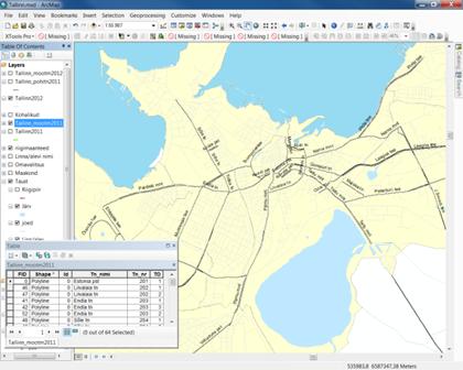
Visualization of various situations and action plans helps to get an objective overview of the current situation, and thus simplifies decision making and activity planning. A complete geographic information system ArcView is a suitable tool for this job.
We own a map data processing and analysis software ArcGIS 10.1 and we are looking forward to cooperating with you in order to deliver thematic maps tailored for your needs, depending on your database and resources:
- area (parish, town, etc.) map;
- road and street map of the area;
 comprehensive plan map of the area;
- theme plan map;
- etc.
Seda veebilehte külastades ja kasutades nõustud sellega, et AS Teede Tehnokeskus kasutab küpsiseid. Nõustun REJECTManage consentPrivacy Overview
This website uses cookies to improve your experience while you navigate through the website. Out of these, the cookies that are categorized as necessary are stored on your browser as they are essential for the working of basic functionalities of the website. We also use third-party cookies that help us analyze and understand how you use this website. These cookies will be stored in your browser only with your consent. You also have the option to opt-out of these cookies. But opting out of some of these cookies may affect your browsing experience.Necessary cookies are absolutely essential for the website to function properly. This category only includes cookies that ensures basic functionalities and security features of the website. These cookies do not store any personal information.Any cookies that may not be particularly necessary for the website to function and is used specifically to collect user personal data via analytics, ads, other embedded contents are termed as non-necessary cookies. It is mandatory to procure user consent prior to running these cookies on your website.